I thought about taking a drone into a cave and looking for new cave sections when exploring the shafts. Knowing that GPS does not work in the cave, I researched whether drones can fly without GPS, and here are the results.
Is it possible to fly a drone without GPS? Yes, drones can definitely fly without GPS. However, flying without GPS is much more difficult and requires a lot of practice. There are different flight modes, from manual to keeping the altitude up to GPS, at which the flying behavior changes radically.
Flying a drone without GPS is like controlling a moving ball on a plate. You have to have very quick reactions to control the situation, and there are many things to consider.
What is important when flying a drone without GPS?
There are different stages of flying a drone. There are the manual, stabilize, altitude hold, and loiter modes. Only for the loiter mode is a GPS signal required. If you want to use the “coming home function,” a GPS signal is also a must.
Generally, it is not a problem to fly a drone without GPS, but you have to keep in mind that the drone will not be as stable as when you use a GPS signal. That means you have to control the drone actively. That’s a big challenge for beginners, but with enough practice, you can fly a drone actively and nobody will be able to tell the difference from a GPS-controlled drone.
To start flying a drone without GPS, it is important to have a wide-open flying area, because you will need a lot of space the first time. Be sure to stand behind the drone so that you’re looking in the same direction as the drone.
Your first time, use the loiter or GPS mode and fly to a safe altitude. Get ready to control the drone actively and then switch to the ATTI mode (altitude hold). You will see that the drone moves away horizontally. That’s because of the wind or because the drone is not calibrated exactly. Now you have to control the drone actively, and you must correct every movement with your controller.
Always remember to switch back to the loiter or GPS mode if you feel uncomfortable and to train your hand to move from the control stick to the mode switch without looking at the controller.
Once you get some practice, you can try to start in ATTI mode and try out the other modes. Be sure you know how the drone will react in each mode and how to control it before you try any of the modes out.
Which flight mode uses GPS, and how do you fly in it?

The most common mode is the loiter, or GPS, mode. In this mode, the drone uses a GPS signal to know its position. Every movement from the surroundings is corrected automatically. It does not matter if the movement is caused by the wind or your hand: The drone will hold its position on all axles (roll, pitch, yaw, throttle). If you control the drone in one direction, the new GPS position will be saved, and the drone will not move further without control signals.
The simplest mode without GPS is the altitude hold mode. In this mode, drones usually use an air pressure sensor to automatically maintain their altitude. However, drones at this altitude will not be held in position, and any wind movement must be actively corrected. It is therefore the simplest mode, because the pilot must actively control “only” three axles (roll, pitch, yaw).
If you are only used to the GPS mode, it is recommended to train yourself on the different flight modes in a wide-open area. Start with the loiter mode and position the drone at a safe altitude, get ready to control the drone activity, and switch to altitude hold mode. You will see that the drone drifts away, and you can correct this drift with a smooth control movement in the opposite direction. You don’t have to correct the altitude: The drone does that automatically.
The next stage of flying without GPS is stabilize mode. This mode allows you to fly the drone manually in all axles (roll, pitch, yaw, throttle). In this mode, the drone will not hold any position. If you make a control movement and take your hands off the control sticks, the drone will automatically level out the roll and pitch. It is a kind of like smooth manual flying. You make your corrections or flight directions, leave out the control sticks, and the drone levels to a horizontal position.
The last mode is manual mode. It is mostly used for acrobatics, and it requires a lot of practice. In this mode, the drone does nothing by itself. If you make a control movement on the roll axle, the drone will keep that position and moves on, until you make exact the same control movement in the opposite direction to stop the drone. There is no altitude hold, horizontal levelling, or position hold—just real drone fun.
What is IOC, and can I use it without GPS?
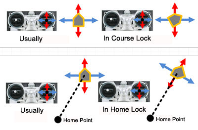
IOC stands for intelligent orientation control and is a useful tool that supports you in different controlling situations. Generally, there are three different IOC modes. Every mode changes the method of controlling the pitch and roll axles of the drone.
Normal flying: During the normal flying mode of IOC, the drone flies forward when you position the control stick forward on the pitch axle. In this mode, no matter which direction the drone is looking, a forward control signal results in a movement forward from the nose direction of the drone.
Course lock: For this mode, the drone saves the direction of the nose after being turned on. Therefore, no matter which direction the drone is looking, a forward control signal generates a movement in the nose direction of the start position. Be careful not to turn yourself during the flight: Otherwise, it could be very difficult to control the drone in this mode.
Home lock flying: This mode uses the home position of the drone. A control signal forward leads to a movement away from your home point radially, and a control signal to the right leads to a circular movement in the clockwise direction of the home point.

Each orientation control mode has its advantages, and it’s up to you to figure out which mode you like best and when to use it. The curse lock and the home lock mode require a GPS signal.
How does GPS work?
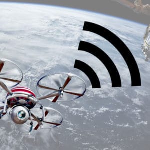
The global positioning system (GPS) is a network of 30 satellites at an altitude of 20,000 km. Each satellite transmits information about its position at its orbit and the current time at regular intervals. The GPS module of the drone receives these signals and calculates how far away each satellite is.
With a minimum of three satellites, the receiver can pinpoint the location of the drone using a process called trilateration, which means that three circles (the distance from each satellite) with different center positions (the satellite position) can only have one crossing point (the position of the drone).
INFO: Einstein and GPS
Einstein’s theory of general relativity predicts that time will appear to run faster under a stronger gravitational pull and slower velocity. Therefore, the clocks on Earth run faster than the clocks on the satellites, and that time dilation has to be considered in the calculation of the position.
What is the “home point” of a drone?

When a drone is powered on, the GPS receiver searches for enough satellites to operate. If the GPS position can be calculated, this first position is saved as the “home point.” This is a safety feature: If the drone loses connection with the controller, it will fly to the home point at an adjusted altitude and land automatically. On some drone flight controllers, you can modify the parameters of this “come home” flight.
You can also program a “Coming Home” switch on your controller and use this feature with an existing wireless connection.
To use this function, make sure that the drone has saved the correct home position. If you start your drone and fly away in a different mode, such as “stabilize mode,” and the GPS receiver reaches its first satellite connection during this flight, that position is saved, and you won’t know where your drone lands.
Can I use autopilot without GPS?
No, every autopilot uses GPS to control the specified route you want to fly. The autopilot calculates the difference between the actual position and the calculated one. Depending on the size of this deviation, the autopilot will send a corresponding control signal to the drone to return to the correct position. Therefore, you need the up-to-date GPS position of your drone to use autopilot.
Do you need the internet to fly a drone?
No, if you control your drone with a tablet or a mobile phone, you only need a WiFi connection between the drone and your device. If you want to use maps during your flight, you can download some before your flight and use them offline during the flight.

